Search
Use keywords to search across notebook descriptions

Use keywords to search across notebook descriptions
Duke of Cambridge public house, Danbury Street. Rheidol Terrace, Danbury Street, Clarence Street, Hanover Street, Baldwin Terrace, Canal Terrace, Grosvenor Street.
Description of Grosvenor Street. Frome Street, William Street, St. Peter Street.
Cambridge Terrace, Devonshire Street, Noel Street, Gerrard Street, Coldbrooke Row, Colebrooke Row, Elliotts Buildings in Elliots Place, Quinn's Buildings in Popham Street.
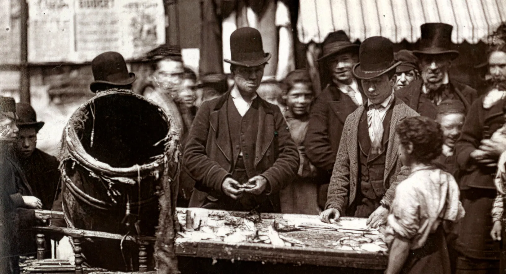
Collins' music hall. Broad Court, Islington Green, Camden Street, Camden Passage, Charlton Place, Little Pierrepont Row.
At Camden Passage, Reverend Snow, rector of St Peter's used to come and preach temperance with his brass band. Camden Passage, Church Street, Chapel Street, Dagmar Terrace, Church Passage.
The numberof police in the Islington division. Jewish community. Additional streets mentioned in the walk:
Description of the boundaries of the walk: on the north by the North London Railway; on the east Compton Road, Ashby Street, Church Road, Southgate Road; on the south by Regents Canal, New North Ro...
Clevedon Street, Union Street, Bull Alley, Bowling Green Street, Gibson Street, Fairy Street, Garnham Street.
Welsh Calvinistic Church, Wilton Square. Wilton Square, Baring Street, Lampeter Street, Cardigan Street, Carmarthen Street, Rosemary Street, Rotherfield Street, Sherborne Street.
Mason indicated a lot of music hall artists live in Canonbury. Almorah Road, Charles Street, Cleveland Street, Oxford Road, Elmore Street, Morton Road, Ecclesbourne Road, Halliford Street, James St...
Canonbury Square, Canonbury Avenue, Carters Yard, Compton Mews, North Cottages, Friends Cottages, Goldsmith Place, Compton Avenue, Northampton Cottages.
Hyde Place West, Hyde Place, Halton Road, Richmond Grove, Sebbon Street, SpencerStreet, Florence Street, Allan Street, Fowler Road.
General remarks on the area. Additional streets mentioned in the walk: Hayman Street, Halton Cross Street [unnamed on map but South of], Pleasant Place, Pleasant Row.
Description of boundaries of walk: on the north Mountgrove Road; on the east by Green Lanes, Petherton Road; on the south by the North London Railway; on the west Highbury Place, Highbury Park and ...
Two buses a minute leave Highbury Corner. Gallia Road, Baalbec Road, Highbury Fields, Highbury Grove, Highbury Barn.
Mentone Street, Kelvin Road [unnamed, South of], Highbury Grange, Kelross Road [unnamed, North of] Aberdeen Road, Aberdeen Park, Northolm Road, Sotheby Road, Ardilaun Road [last 3 unnamed, North o...
Public house on corner of Montgrove Road is called the "Sluice House" Many Jews live in Highbury New Park. Mountgrove Road, Canning Road, Wyatt Road, Herrick Road, Highbury New Park, Stradbroke Roa...
Little entertainment for young people in the evenings. Betting in the area.
Information concerning plain clothed police detectives Additional streets mentioned in the walk:
Description of picture of the Duchess of Devonshire buying a vote for Fox with a kiss on the wall outside the Jolly Butchers public house on Fairy Street. Lawrence Terrace, Chapel Court, Kynaston A...
Police and bribes by publicans. Resolution that licenses should be granted subject to a promise not to serve beer to children fetching beer for their parents.
Danger to young girls, general servants, fetching beer from public houses. Licensing Act 1874.
Consequences of free trade in licensed houses and the values of public houses.
Manager of Penbury Arms, Amhurst Road, Hackney, The Unicorn at the junction of Commercial Street and Shoreditch, and three other public houses in Tottenham, Denmark Hill and Homerton.
The Penbury Arms [Amhurst Road, Hackney] has seven bars, two which are for men only. The types of customers which frequent public houses. Drunken men will not be served, police help to escort drunk...
Payments to police. Glasses becoming more popular than pint pots.
Separate room for children and servant girls to collect beer. Rising prices of public houses
General remarks on Stoke Newington. Hamilton Place, Leswin Road, Bayston Road, Darville Road, Tyssen Road, Union Road, Johns Road.
Children fetch beer from public houses. Betting in the area.
Description of boundary of walk: on the north Furlong Road; on the east Holloway Road and Upper Street; on the south Chapel Street; on the west Barnsbury Road, Thornhill Road, Upper Park Street, Li...
Gibson Square, Liverpool Road, Barford Street, Agricultural Hall, King Edward Street, Liverpool Street, Parkfield Street, York Cottages.
Street market on Chapel Street. Charles Street, Chapel Street.
Brothels in the area. Union Square, Chapel Place, White Lion Street, Warren Street, Barnsbury Road, Denmark Road, Denmark Grove, Richard Street, Sermon Lane, Mount Zion, Russell Place.
Rents in Milner Square. Barnsbury Street, Milner Square, St George's Terrace, Richmond Road, Stonefield Street, Cloudesley Square.
Cloudesley Street, Cloudesley Place, Milton Yard, Cloudesley Road, Thornhill Gardens, Thornhill Road
Bookmakers in the area. Off licence and grocers, Brooksby Street which includes prices of beer. Lonsdale Square, Prospect Place, John Street
Brooksby Street, Upper Park Street, Furlong Road.
Bookmakers in the area. Union Road, Crane Grove, Wilson's Yard.
Animals are driven on their way to the metropolitan cattle market through Islington.
The boundaries of the N Police Division. Additional streets mentioned in the walk:
Description of boundaries of walk: on the west by Great Northern Railway; on the north Seven Sisters Road; on the east Blackstock Road; on the south Aubert Park. Part of the parishes of St Thomas, ...