Search
Use keywords to search across notebook descriptions

Use keywords to search across notebook descriptions
Index of interviews, address and nature of interview.
1897 George H.Duckworth's Notebook: Police and Publicans District 10 [Bethnal Green East], District 15 [South West Islington], District 17 [Upper Holloway]
Beales Restaurant. Tollington Road, Bovay Place, Bovay Street, Hertslet Road, Enkel Street, Arthur Road, Roden Road, Mayton Street, Pakeman Street.
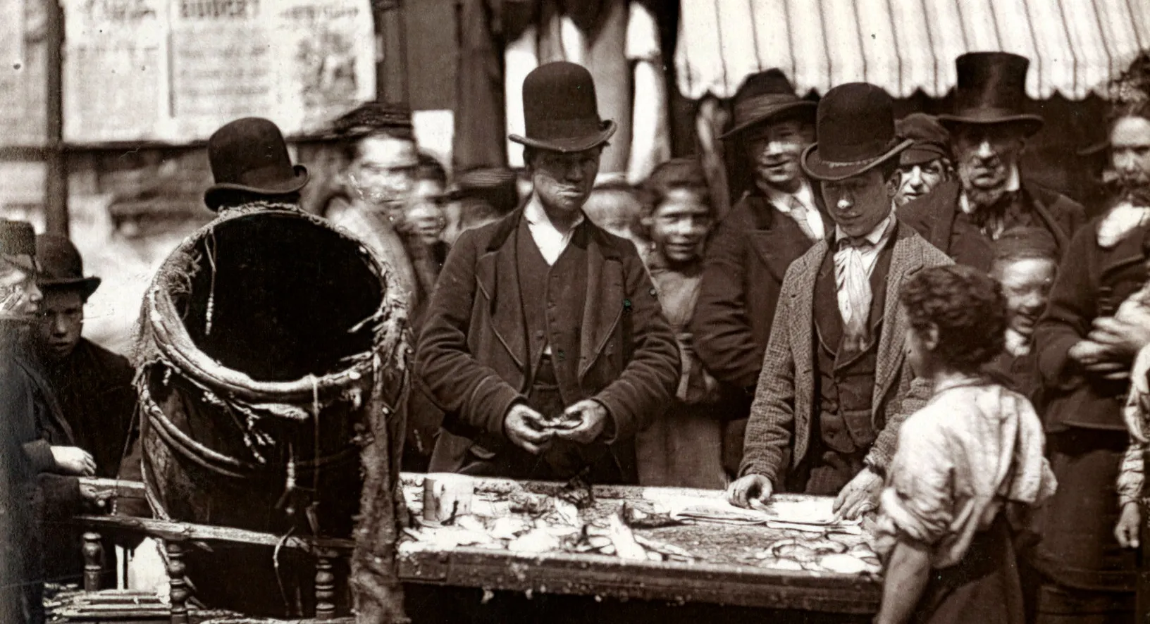
Visit to Charlie who keeps a coffee shop on the corner of Blenheim Road and Hornsey Road. Blenheim Road, Hornsey Road.
Description of a skittle match taking place downstairs [in the above coffee house on the corner of Blenheim Road and Hornsey Road]
Incident concerning stolen pickles. Public House called Prince Alfred but known as "The War Office", corner of Marlborough Road and Cottenham Road. Marlborough Road, Cottenham Road.
Visit to the Battenburg Club [Battenberg Club?], gambling club.
Kinsdown Road is a London general bus depot where 1500 horses are stabled. Alexander Road, Landseer Road, Stanley Terrace, Montpellier Road, Kingsdown Road, Fortnam Road, Kiver Road, Davenant Road,...
Visit to the German Dramatic Club, Upper Street, Islington. Additional streets mentioned in the walk:
Description of the boundaries of the walk: on the north by the Camden Road; on the east Holloway Road, N.L.R. [North London Railway]and Caledonian Road; on the south Brewery Road; on the west York ...
Balmoral Grove, York Road, Gooding Road, Halse Street, Surr Street, Fakenham Street, Hillmarton Road, Penn Road, Hartham Road, Cardozo Road, Freegrove Road, Hartham Road.
Hungerford Road East, Penn Road, Beacon Hill, Camden Road, Hilldrop Crescent, Williamson Street, Wartlers Road.
Housing on Loraine Place. Loraine Place, Walters Mews, Stock Orchard Street, Stock Orchard Crescent.
Information concerning the cattle market including the price for horses. Additional streets mentioned in the walk:
Description of the boundaries of the walk: on the north the North London Railway; on the east Holloway Road, Liverpool Road; on the south Bride Street; on the west Wellington Road. Part of the pari...
Grove Street, Hope Street, Hope Place, John Street, James Street, Charlotte Place, Milton Place.
Eden Grove, Burnard Street, Hornsey Street, Wellington Road.
Rhodes Street, Victoria Road, St. James' Road, Chalfont Road, Sheringham Road, Charles Street, Hollingsworth Road.
Small shops in Hornsey Road. Cornwallis Road, Marlborough Road, Ellenborough Road, Cottenham Road, Kingsdown Road, Whewell Road, Mitford Road, Hornsey Road, Pine Grove.
Lowther Road, Wellington Road, Crossley Street, Hides Street, Bride Street, Dorinda Street.
Description of the boundaries of the walk: on the north Roman Road, Bride Street; on the east Holloway Road, Albion Road, Liverpool Road, Barnsbury Park, Barnsbury Road; on the south Copenhagen Str...
Bride Street, Barnsbury Grove, Cornelia Street, St. Clement Street, Offord Road.
Cumberland Street, Market Street, Westbourne Road, Arundel Square, Ellington Street, Madras Place, Ringcroft Road, Palmer Road.
Wellington Place, Barnsbury Park, Thornhill Road, Belitha Villas, Hemingford Road, Huntingdon Street, Offord Street.
There is a need for a playground in the district. Thornhill Crescent, Thornhill Square, John Street, Thornhill Grove, Lambert Terrace, Maria Terrace, John Street, Mountford Crescent, Mountford Plac...
Alma Terrace, Richmond Road, Albion Grove, Richmond Crescent, Boxworth Grove, Sheen Grove, Gainford Road, Pulteney Street, Pulteney Terrace, Alma Grove, Copenhagen Street.
Betting in area. Matilda Street, Grace Street, Everilda Street, Cab Yard.
Prostitution in the area. Additional streets mentioned in the walk:
Description of the boundaries of the walk: the north Copenhagen Street; on the east Barnsbury Road; on the south Half Moon Street [Halfmoon Crescent?] and the Regents Canal; on the west Caledonian ...
Italians live in Roads Street. There are a few suspected brothelS in the area. Inspector Dyball disapproves of grocers licences. Pine Grove, Gladstone Street, Roads Street.
Sunday gambling Bryan Vale. Bryan Vale, Bryan Place, Charlotte Street, Muriel Street, Charlotte Terrace.
Payne Street, Vittoria Place, Vittoria Street.
Description of Victoria Street. Copenhagen Street.
Barnsbury Road, Maygood Street, Half-Moon Street [i.e. Halfmoon Crescent].
Customers of public houses. Additional streets mentioned in the walk:
Description of the boundaries of the district: on the north Tottenham and Hampstead Railway; on the east Holloway Road; on the south Camden Park Road; on the west Kentish Town Road and Brecknock Ro...
Anson Road, a well-to-do district. Carleton Road, Union Road, Huddleston Road, Dalmeny Road, Dalmeny Avenue, Anson Road.
Crayford Road, Tabley Road, Bardolph Road, Cardwell Road, Hilton Road, St. Peters Road, Camden Road, Parkhurst Road, Tufnell Park Road, Mercers Road, Fairsmead Road, Tavistock Terrace, Wedmore Street.
There is a demand for small houses in the area.
Cromwell Road, Hampden Road, Wedmore Gardens, Tytherton Road.
Beversbrook Road, Gatcomb Road, Campdale Road, Tufnell Park, Warrender Road, Fulbrook Road, Ward Road, Brecknock Road, Southcote Road, Lady Margaret Road. Celia Road, Hugo Road, Corinne Road.
General remarks on the district. Additional streets mentioned in the walk:
Description of boundaries of the walk: on the north Hornsey Lane; on the east Whitehall Park, Harberton Road, Archway Road and Holloway Road; on the west Dartmouth Park Hill. Part of the parishes o...