Search
Use keywords to search across notebook descriptions

Use keywords to search across notebook descriptions
Poverty in the area. Shadwell Street, Spring Gardens, Cable Street, Hardinge Street, Alfred Street, Drewton Street, Thomas Street, Ronald Street, Steel's Lane, Devonport Street.
Description of boundaries of walk: on the north Commercial Road East; on the east Johnson Street; on the south Cable Street; on the west Watney Street. Part of the parishes of Christ Church St Geor...
Description of houses in Cowley Street. Cowley Street, Yule Court, Cornwall Street, Station Place.
Cross Court, Dean Street, Martha Street, Spencer Street, Sheridan Street, Tarling Street.
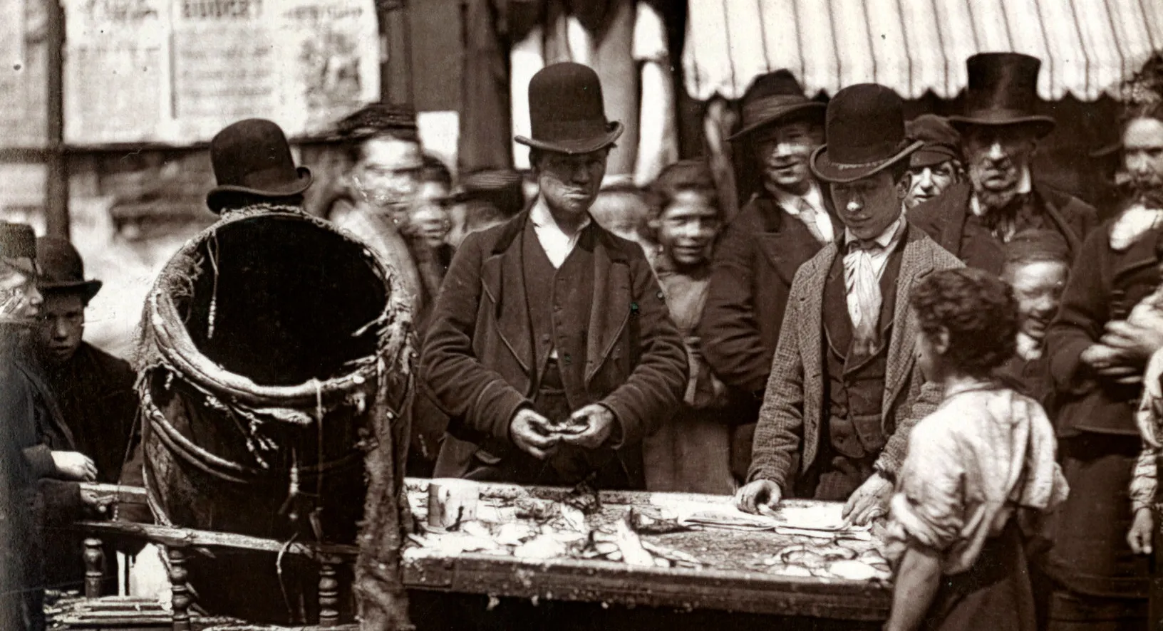
Jews in the area. Watney Street is a market street, prices of goods. Tarling Street, Watney Street.
Jews in Sutton Street. Ladies in "East End clothes" Additional streets mentioned in the walk: Blackesly Street, Dean Street, Sutton Street.
Description of boundaries of walk: on the north Commercial Road East; on the east Watney Street, Cable Street and Glanis Road; on the south Shadwell High Street, St. George's Street; on the west Ca...
Whites Gardens, Hungerford Street, Fenton Street, Morris Street, Tait Street, Mary Street, Chapman Street, Agra Place, Tillman Street, Chapman Place, Anthony Street, Cornwall Street.
Prospect Place, Cable Street, Walburgh Street, Walburgh Place, Goodhart Place, Little Ann Street, York Place, Lower Fenton Street.
Jews living in Little Turner Street. Buross Street, Fenton Street, Jane Street, Richard Court, Richard Street, Little Turner Street, Barrett Street, Kinder Street.
Jews living in Common Street Road. Sly Street, Cannon Street Road, St. Georges Street, Old Gravel Lane, Harris Terrace, Russell Court, Ratcliffe Street.
Redevelopment of Dellow Street. Dellow Street, Albert Street, Sage Street, Settles Buildings, Twine Court, Newton's Rents.
Changes to district Additional streets mentioned in the walk: Shadwell High Street, Market Buildings, Mercer Street, David Lane, Peel Alley, Glamis Road.
Description of boundaries of walk: on the north Green Street; on the east Warley Street, Devonshire Street and Cleveland Street; on the south Mile End Road; on the west Cambridge Road. Part of the ...
Description of boundaries of walk: on the north St George Street and Shadwell High Street; on the east Glanis Road; on the south by River Thames; on the west Bird Street, Trench Street, Red Lion St...
Description of Whitehorn Place, cockney Irish live here. Coleman Street, Fox and Goose Yard, Whitethorn Place, Pruson Street, Malay Street, Agatha Road, Rygate Street.
Hillard Court, Clegg Street, Cinnamon Street, Ship Street, Brewhouse Lane, Queen's Head Alley, Red Lion Street, Upperwell Alley, Grocers Court, Church Court.
Recreation ground Red Lion Street. Bird Street, Red Lion Street, Green Bank, Love Lane, Lowder Street [York Place on map], Watt Street [i.e. Watts Street, Calvert Street on map].
Raymond Street, Meeting House Alley, Chandler Street, Bostock Street, Red Lion Street, Taylors Rents, Worcester Street, Worcester Court, Old Gravel Lane.
Suicides at the bridge in New Gravel Lane. Rycroft Court, Starch Yard, Pennington Street.
Religious influences in Wapping. Lavender Place, Chigwell Hill, Star and Garter Yard, West Gardens, Elbow Lane, Dukes Court.
Industries in Wapping. No Jews live in Wapping; some cockney Irish. Public houses in area. Additional streets mentioned in the walk:
Usk Street, Wartler Street, Morpeth Street, Knottisford Street, Tuscan Street, Bonwell Street, Butler Street, Digby's Walk, Digby Street, Lansdell Place.
Beer houses in Wapping. Jews in the East End.
Children are sent to collect beer for their parents.
Expectation of public servants that they will be given free drinks ie postman, road sweeper
Employees of the public house. Consequences of increasing or decreasing the number of licensed houses.
Description of the boundaries of the district: on the north by the Hertford Union Canal; on the east Ellesmere Road, Legal Road, Antill Road, Grove Road, Bow Road, South Row, City of London Cemeter...
Portman Place, Atlas Road, North Street, Sceptre Road, Ann Street, James Street, Essex Street.
Iron dealer on Essex Street. Reputation of Cornwall Square assigned black on the map, many juvenile thieves live here. Cornwall Road, Cornwall Square, West Street, Portman Place, Atlas Road.
Hardy's Place, Railway Place, Entick Street, King Street, Doveton Street, Devonshire Street, Cleveland Street.
Description of boundaries of walk: on the north Old Ford Road; on the east Bonner Street; on the south Green Street; on the west Cambridge Road. Part of the parishes of St John and St James the Les...
Coburg Place, Whitehead Street, Union Buildings, Union Place, Cleveland Road, Bellevue Place, Cleveland Grove, Brunswick Place, Cambridge Road, Key Street, Faith Street.
Convicts reporting to police station. Additional streets mentioned in the walk:
Policy of fixed points and short patrols for police duties.
Cleanliness rules for inhabitants of buildings. For example, Quinn's Buildings, Russia Lane.
A large number of the inhabitants of Whitechapel cannot speak English. Stabbing cases in the district. Polish, Jews and Russians in district, mostly strong socialists.
Effect of spirits drunk in large amounts. Drunkenness and women